Bring the Subsurface Into Focus

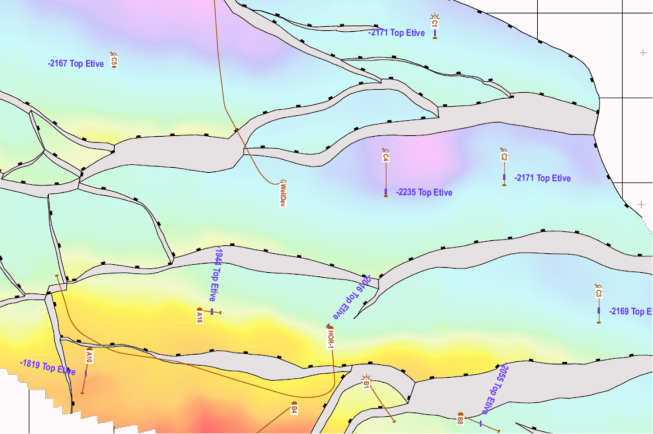
Every decision in energy exploration depends on how clearly you can see the subsurface. True clarity doesn’t come from hard data alone. It’s shaped by how the data is modeled, mapped, and communicated. Yet for many teams, clear decision-making is slowed down by scattered data, inconsistent standards, and time-consuming updates.

Petrosys Group helps energy companies transform complex subsurface data and geological information into reliable, visually compelling representations that teams can trust. Our mapping and modeling solutions make understanding the subsurface faster and more consistent, guiding confident decisions, and bringing your data and projects into sharper focus.

Build Subsurface Maps & Models That Drive Results

Subsurface mapping and modeling is part art and part science, bringing together technical knowledge and business understanding. Traditional mapping tools can be rigid and disconnected, forcing geoscientists to spend more time preparing data than interpreting it. Our solutions combine technical precision with practical insight – enabling you to build accurate, publication-quality maps that display data and inspire action.

Map the subsurface

Map and Model the Subsurface With Rigour

When maps take too long to update or data comes from inconsistent sources, confidence erodes and decisions slow down. Every map and model you produce should strengthen credibility, whether in technical meetings, stakeholder presentations, or licensing rounds.

With our mapping and modeling tools, you can:

  • Produce publication-ready maps of current interpretations in minutes, saving hours of manual formatting.

  • Display and combine data directly from popular E&P and GIS applications, reducing export and conversion work.

  • Accurately map data from multiple coordinate systems, avoiding costly spatial errors.

  • Edit contours, faults, and outlines with geological insight and control, so expert knowledge stays central to every result.

From Subsurface Data to Strategic Decisions

From exploration to appraisal to development and beyond, teams often struggle to connect interpretations, spatial data and outputs into a single coherent picture. Our solutions make it easier to bring all the subsurface elements together into a single, trusted view.
PRO

PRO supports consistent subsurface mapping and modeling, enabling teams to move from interpretation to volumetric estimation with confidence, accuracy, and accountable results.

Who Uses Our Subsurface Mapping & Modeling Tools?

In short, everyone who relies on accurate maps to explain the subsurface!

hardhat icon

Geoscientists

Create and refine maps that accurately represent geological complexity, integrating data from multiple sources without time-consuming conversions.
gear magnifying glass icon

Data Managers

Maintain trusted data inputs across systems, ensuring that what feeds your maps and models is accurate, consistent, and traceable.
gear IT icon

Exploration and Development Teams

Collaborate seamlessly across disciplines with tools that connect data, streamline updates, and reduce duplication errors.
cylinder with square, triangle, circle

Executives, Project Owners, and Decision-Makers

View results you can trust: clear, presentation-ready outputs that support informed decisions and demonstrate value.

Advanced Technology for Connected Mapping & Modeling

When mapping, modeling, and data management work together, the result is more than a picture of the subsurface. It’s a powerful strategic advantage.

Our integrated solutions connect geological information with operational planning and business goals, helping teams evaluate opportunities faster and communicate with confidence. With Petrosys Group, the science behind every decision is clear and easy to act on.

FAQs

About Petrosys’ Mapping & Modelling Solutions

How do better mapping and modeling improve decision-making?

High-quality maps and structural models provide a clear picture of the subsurface, helping teams better identify opportunities, evaluate risks, and support well-informed recommendations. When outputs update quickly and consistently, stakeholders from technical reviewers to executives gain greater confidence in the geological reasoning and data behind each decision.

What makes Petrosys Group different from other mapping software providers?

Petrosys Group combines decades of geoscience expertise with technology specifically built for subsurface data. PRO our advanced subsurface mapping and modeling software connects directly to interpretation platforms, GIS systems, and databases – meaning that our maps and models are not only visually compelling, but are always grounded in trusted, traceable, up-to-date information.

Can subsurface mapping and modeling integrate data from different systems?

Yes! Our mapping and modeling solutions are designed to connect with a wide range of E&P applications, GIS systems, and spatial databases. This reduces export and reformatting work, improves data consistency across projects, and helps maintain a reliable, single view of the subsurface.

textured blue/yellow background

Map With Precision. Model With Confidence.

See how Petrosys Group’s mapping and modeling solutions can bring greater clarity and consistency to your work. Request a demo to see how we can help you.